Intended for healthcare professionals
Open access
Research article
First published online April 2, 2026

Adaptive intelligent grey wolf optimization for UAV path planning in complex mountainous areas

Abstract

Unmanned aerial vehicles (UAVs) performing transportation tasks in complex mountainous areas face challenges from unstructured terrain and the need for dynamic obstacle avoidance. The Grey Wolf Optimization (GWO) algorithm is characterized by its simple structure and minimal parameter tuning, and has demonstrated strong performance in practical applications. However, it suffers from slow convergence speed and a strong tendency to become trapped in local optima. Therefore, this study proposes an Adaptive Intelligent Grey Wolf Optimization (AIGWO) algorithm for UAV transportation path planning in complex mountainous environments. To objectively characterize the mountainous environment and quantitatively assess path quality, a three-dimensional spatial model integrating static terrain, dynamic obstacles, and random noise, together with a multi-objective evaluation function considering path length, flight altitude, and turning angle, were constructed. In order to accelerate convergence, an adaptive search strategy was developed to dynamically balance global exploration and local exploitation. For enhancing the algorithm's exploitation capability and improving population diversity, a candidate position update strategy based on dimensional learning was proposed. Furthermore, dynamic obstacle evolution models and random noise interference mechanisms were established to rigorously evaluate the algorithm's robustness. Finally, the proposed AIGWO algorithm was compared with five advanced algorithms (namely GWO, IGWO, LGWO, PSO, and GA). The results demonstrate that AIGWO achieves a reasonable running time while reducing the number of convergence iterations by 38.8%, shortening the flight path length by 4.6%, and improving the optimal fitness value by 20.0% compared to the benchmark algorithms. These findings confirm the significant superiority of the proposed algorithm for UAV transportation path planning in complex mountainous areas.

Introduction

Unmanned aerial vehicles (UAVs) are widely deployed in both military and civilian domains, encompassing applications such as reconnaissance, surveillance, search and rescue, disaster response, logistics support, and environmental monitoring, all of which impose stringent requirements for efficient, safe, and reliable path planning.13 Particularly in complex mountainous regions, UAVs play a critical role, yet this harsh environment presents significant challenges, including unstructured terrain, dynamic weather conditions, uncertain obstacle placement, and demanding constraints on flight stability, energy efficiency, and real-time adaptability during prolonged missions.
Early path planning algorithms, such as Dijkstra's algorithm4 and the A* algorithm,5 rely on discrete node-based shortest path computations and are primarily suited to simple static scenarios. However, they struggle to adapt to high-dimensional mountainous environments and dynamic tasks.68 Later, metaheuristic approaches have been widely adopted for UAV path planning. Particle Swarm Optimization (PSO)9 simulates swarm foraging behavior and exhibits excellent performance in small-scale static tasks. Ant Colony Optimization10 achieves path coordination through pheromone accumulation, rendering it suitable for structured environments. Deep reinforcement learning-based methods11 depend on scenario-specific training data to enable adaptive path adjustment, making them well suited to fixed-type tasks.
Recent studies have significantly advanced UAV path planning across diverse scenarios and strengthened metaheuristic theoretical frameworks. For example, Tian et al.12 proposed the TSEB-DDPG algorithm for UAV path planning in complex urban environments, while Wang et al.13 developed the RLTARO algorithm by integrating reinforcement learning and thermal guidance for mountainous UAV formation path planning. Owing to its simple structure, minimal parameter tuning, strong global search capability, and rapid convergence, the Grey Wolf Optimization (GWO) algorithm14 has been widely adopted to address UAV path planning in complex environments. Recent improvements to GWO include the following representative works: Liu et al.15 employed Gaussian mutation and helical functions to escape local optima. Dezfouli et al.16 introduced a cosine transfer function to transform continuous GWO into a binary variant for discrete problems. Duan et al.17 incorporated Sine Cosine Algorithm into the position updates of leading wolves to mitigate premature convergence, and Yu et al.18 proposed HGWODE, a hybrid of GWO and differential evolution, to balance exploration and exploitation. In addition, Kiani et al.1921 have developed scenario-specific solutions, including two 3D path planning methods based on I-GWO and Ex-GWO for collision-free multi-UAV coordination, the Adapted-RRT hybrid algorithm to optimize path optimality and execution efficiency for autonomous robots, and adaptive metaheuristic methods for collision-free path generation in farmland robots. They also designed a dynamic IIoT protocol22 for industrial resource management and path planning. Anka et al.2326 have further advanced metaheuristic theory through a comprehensive study on the Mountain Gazelle Optimizer for balanced exploration and exploitation in complex multi-objective tasks, the Ex-ChOA algorithm for enhanced convergence in high-dimensional constrained problems, the HGPSO method integrating Genetic Algorithm (GA) and PSO for IoT sensor deployment, and a review of Sand Cat Swarm Optimization for stable and low-cost optimization in real-world applications.
Notably, although the aforementioned studies offer significant contributions within their respective domains, they have not been tailored to the unique requirements of UAV transportation in complex mountainous areas. In particular, existing GWO variants typically rely on isolated or static enhancements—such as single-parameter adaptation or fixed perturbation mechanisms—rather than an integrated design tailored to the target scenario. To meet the specific demands of UAV transportation tasks in such challenging terrain, this study proposes an Adaptive Intelligent Grey Wolf Optimization (AIGWO) algorithm. Unlike incremental combinations of isolated strategies, the novelty of AIGWO lies in the synergistic integration of multiple mechanisms tailored to this mission context: (1) Construction of a multi-objective evaluation function incorporating path length, flight altitude, and turning angle to accommodate the multi-dimensional constraints of UAV transport; (2) Design of an adaptive search strategy to accelerate convergence by dynamically balancing global exploration and local exploitation; (3) Development of a candidate position update strategy based on dimensional learning to maintain search diversity and mitigate premature convergence to local optima; (4) Establishment of a dynamic obstacle motion model and a path-planning simulation environment subject to random noise interference to validate the algorithm's robustness. Finally, the AIGWO algorithm was experimentally compared with five advanced algorithms, thereby demonstrating its superior performance for UAV transportation.

Construction of map models and evaluation functions

For UAV performing transport tasks in complex mountainous areas, accurate path planning is inseparable from effective environmental cognition and quantitative evaluation. To objectively describe and evaluate such environments, a three-dimensional spatial model and multi-objective evaluation functions are constructed. The latter is also used to assess the effectiveness of the proposed algorithm.

Map models

Complex mountainous environments are highly unstructured. Fixed geographic elements such as mountain ranges can be clearly presented by static maps, while dynamic obstacles such as mountain vehicles and wildlife and random noise, which are rarely considered in traditional methods, exist in real mountainous regions. Thus, three-dimensional spatial maps integrated with dynamic obstacles and random noise are established.
Details of the static terrain models, dynamic obstacles, and random noise are presented as follows.

Static terrain model

Static terrain models are capable of accurately depicting fixed elements in complex mountainous areas, providing a stable base environment for path planning.27 Such models consist of a digital terrain model and a mountain hazardous area model.
The digital terrain model is expressed as:
z=a×sin(y+a)+b×sin(x)+c×cos(d(y2+x2))+e×cos(f(y2+x2))+g×cos(y)
(1)
Where x,y are horizontal coordinates, z is correspond height; a,b,c,d,e,f,g are coefficients, whose adjustment can alter mountain terrain characteristics.
The mountain dangerous area model is shown below:
((xxt)2+(yyt)2=r2)(z=[0,h])
(2)
Where xt,yt denotes the location coordinates of the mountain dangerous area, r denotes the radius of the dangerous area, and h denotes the height of the dangerous area.
The mountain terrain model is as follows:
h(x,y)=i=1khi×exp((xAi,1)2ai2(yAi,2)2bi2)+h0
(3)
Where x,y for the water plane coordinates, h(x,y) for the corresponding mountain peak height; hi represents the peak elevation, Ai,1,Ai,2 for the peak of the highest point of the corresponding horizontal coordinates, ai,bi represents the peak along the x,y direction of the slope variable, ai,bi the smaller the slope of the peak is steeper.
To simplify the problem rationally, the UAV is equated to a point in the 3D spatial model for efficient path planning, which also helps to simplify the collision detection with mountain terrain and obstacles during transportation.

Dynamic obstacles

Dynamic modeling focuses on changes of moving elements in complex mountainous areas to capture real-time environmental dynamics. Moving obstacles with different motion patterns (linear, circular, random) are simulated to provide a realistic and complex test environment for path planning.
(1) Linear motion:
Pi(t+Δt)=Pi(t)+ViΔt
(4)
The boundary reflection conditions are as follows:
{Vi(x)Vi(x),ifPi(x)(t+Δt)[0,200]Vi(y)Vi(y),ifPi(y)(t+Δt)[0,200]
(5)
Where Pi(0)R2 denotes the initial position, ViR2 is the velocity vector, and Δt=0.1s is the time step.
(2) Circular motion:
θ(t+Δt)=θ(t)+ωΔt
(6)
Pi(t+Δt)=c+R[cosθ(t+Δt)sinθ(t+Δt)]
(7)
Where ω=0.1rad/s,c=[100,150], R=50 .
(3) Random motion:
Vi5(η0.5),(ηU(0,1)2)
(8)
Pi(t+Δt)=Pi(t)+ViΔt
(9)
Multi-mode motion rules for dynamic obstacles are defined mathematically, supporting mixed scenes of multiple motion mode and providing a high-fidelity test environment for the path planning algorithm.

Random noise

Environmental measurements in complex mountainous regions are susceptible to signal interference and other factors, leading to unavoidable measurement errors. These errors and interferences are simulated by introducing random noise to improve the model's adaptability and robustness.2829
M(i,j)=f(i,j)+ϵξi,j,i[1,Nx],j[1,Ny]
(10)
Where f(i,j) is the underlying terrain function, ϵ=0.2 is the noise intensity factor, ξi,jN(0,1) is the standard Gaussian distributed random variable, Nx is the horizontal dimension, and Ny is the vertical dimension.
This simulates terrain uncertainty in real mountainous environments caused by measurement errors, natural undulations, or sensor noise, generating non-idealized complex terrain for more practical test scenarios of the optimization algorithm.

Multi-objective evaluation function

To objectively evaluate complex mountainous environments and verify subsequent algorithm effectiveness, a multi-objective evaluation function (path length, flight altitude, turning angle) is constructed, tailored to mountain transport core requirements: energy conservation, safety, and flight stability.
(1) Path length: A shorter path reduces UAV fuel consumption and transport time, lowering transport costs and improving delivery timeliness. It is thus adopted as a key evaluation index, with the expression:
P=dx2+dy2+dz2
(11)
Where dx,dy,dz denote the coordinate incremental, dx2+dy2+dz2 denotes the Euclidean distance. The total path length is obtained by summing all increments.
(2) Flight altitude: Stable flight altitude adapting to mountain terrain undulations ensures the safety of transported materials and reduces the impact of mountain airflow on flight stability. The expression is:
H=(Zmean(Z))2
(12)
Where Z is the altitude vector, and mean(Z) is its mean value. A smaller H indicates more stable altitude.
(3) Flight turning angle: A smaller turning angle ensures stable and smooth flight, reducing sway and collision risks. The expressions are:
C(i)=Dx(i)×Dx(i+1)+Dy(i)×Dy(i+1)+Dz(i)×Dz(i+1)Dx(i)2+Dy(i)2+Dz(i)2×Dx(i+1)2+Dy(i+1)2+Dz(i+1)2
(13)
C=i=1size(Dx,2)1(cos(φ)C(i))
(14)
Where Dx,Dy,Dz are differences of sequences x,y,z, and φ=π/2. A smaller C(i) indicates smoother turning.
In summary, the multi-objective evaluation function for UAV mountain transport path planning is:
f=ω1×P+ω2×H+ω3×C
(15)
Where P denotes path length, H denotes height, and C denotes turning angle.30 The weighting coefficients are set as ω1=0.4,ω2=0.4,ω3=0.2, prioritizing energy conservation and safety for mountain transport tasks.

AIGWO

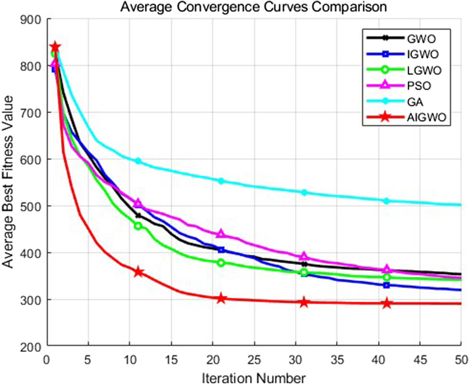
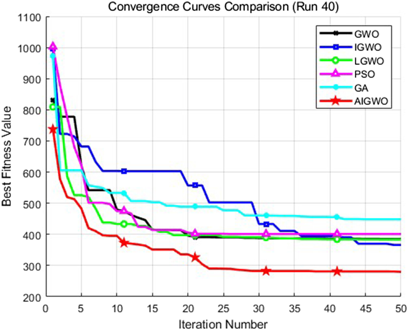
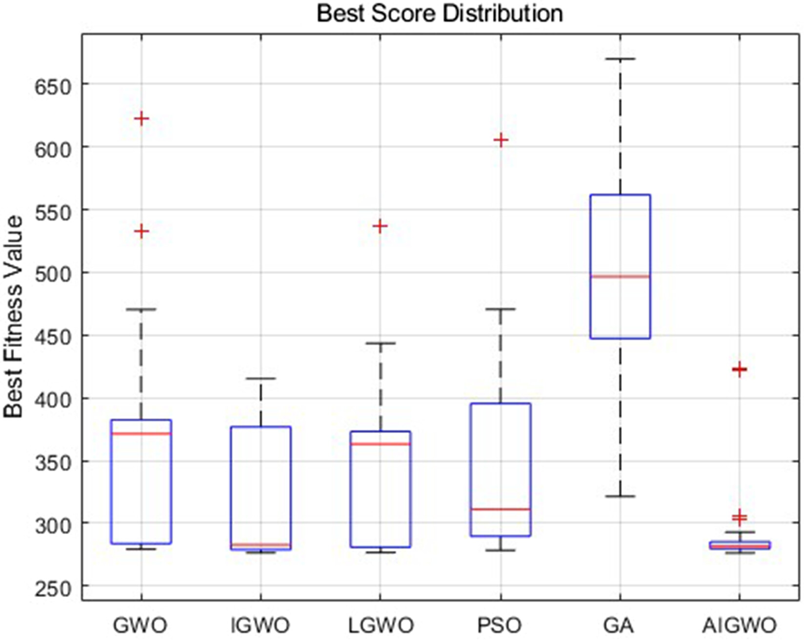
GWO is favored for UAV path planning due to its simple structure and minimal parameter tuning requirements. However, it faces limitations such as slow convergence and susceptibility to local optima, which are exacerbated in complex mountainous transport scenarios characterized by unstructured terrain, dynamic obstacles, and large-scale search spaces. To address these problems, an AIGWO is proposed. In order to accelerate convergence of the algorithm, an adaptive search strategy based on an adaptive decay factor and search method is designed. And a candidate position updating strategy based on dimensional learning is designed to jump out of the local optimum. The following section will describe in detail.

GWO

GWO simulates the social hierarchy and hunting behavior of grey wolf packs, with four hierarchical roles (α,β,δ,ω) corresponding to the optimal, suboptimal, third-best, and remaining solutions. The hunting process is mathematically modeled through position updates guided by α,β, and δ wolves, with core formulas defined as:
D=|C×XP(t)X(t)|
(16)
X(t+1)=XP(t)A×D
(17)
a=2t×2T
(18)
A=2×a×r1a
(19)
C=2×r2
(20)
Where X(t) and XP(t) denote the position vectors of grey wolves and prey, respectively; t and T represent the current and maximum iterations; a is the linear decay factor; r1 and r2 are random vectors within [0,1]; A and C are the exploration and random weight coefficients. The position update of ω wolves is guided by α,β, and δ wolves:
X(t+1)=(X1+X2+X3)3
(21)
Where X1,X2,X3 are positions derived from α,β, and δ wolves, respectively. Despite its simplicity, GWO lacks adaptability to mountainous transport scenarios, leading to insufficient diversity and premature convergence.

Adaptive search strategy

To enhance AIGWO's adaptability to complex mountainous terrain characterized by rugged landform and scattered obstacles, an adaptive search strategy is designed to dynamically balance global exploration and local exploitation. Global exploration targets traversing large-scale unstructured terrain, while local exploitation focuses on optimizing path quality. Integrated into this strategy are adaptive decay factor adjustment based on iteration progress and population diversity, multi-scale search methods, and simplified Levy flight, which collectively enhance the algorithm dynamic responsiveness and search efficiency and accuracy in path planning.

Adaptive decay factor

Instead of the linear decay of a in traditional GWO,31 a diversity-aware decay factor is adopted to adapt to the dynamic distribution of mountainous terrain. The diversity ratio γ is calculated based on inter-individual distances to reflect population dispersion:
γ=μcurrentμinitial
(22)
base=2×(1tT)
(23)
=base×(0.5+0.5×γ)
(24)
Where μcurrent and μinitial are the current and initial average inter-individual distances. The base decay base decreases linearly with the number of iterations. is constrained within [0.1, 2] to ensure stability: a larger enhances exploration when the population is dispersed, adapting to unknown mountainous areas, while a smaller accelerates exploitation when the population aggregates, optimizing paths in known safe zones.

Adaptive Search Modes

A single search mode fails to balance efficiency and comprehensiveness in complex mountainous transportation. Three adaptive search modes are designed, switched based on the positional relationship between the leading wolf and potential optimal paths to improve search flexibility and accuracy. The key modes and their calculations are as follows:
(1) Initial search: Guides the swarm towards potential optimal paths by weighting the top three wolves, accelerating early convergence in unknown mountainous areas:
X(t+1)=0.5×X1+0.3×X2+0.2×X3
(25)
(2) Breadth search: Expands the search scope by referencing the swarm's average position, suitable for exploring wide mountainous regions and maintaining population diversity:
X(t+1)=Xα(t)(1tT)+(XM(t)Xα(t))rand
(26)
XM(t)=1Ni=1NXi(t)
(27)
Where Xα(t) is the position of the alpha wolf at iteration t; XM(t) is the average position of the swarm; (1t/T) controls exploration intensity; and rand[0,1] introduces randomness.
Where X(t+1) denotes the position after (t+1) iterations and Xα(t) denotes the position of α wolf after the t iteration. (1t/T) is explored through controlled iterations. XM(t) denotes the average of all positions after the t iteration. rand is a random number in the interval [0,1].
(3) Depth search: Adopts simplified Levy flight for precise path optimization near mountain obstacles, avoiding local optima:
X(t+1)=Xα(t)×Levy(D)
(28)
Where X(t+1) denotes the position after (t+1) iterations. Levy(D) is the Levy flight distribution function,32 and D denotes dimension. It is calculated as follows:
Levy(D)=s×u|v|β×(X(t)Xα(t))
(29)
Where s=0.01,β[0,2],uN(0,σu2),vN(0,1). σu is computed as follows:
σu=(Γ(1+β)×sin(πβ2)Γ(1+β2)×β×2(β12))1β
(30)
Where Γ is the conventional gamma function. A random β[0,2] is selected in each Levy flight iteration, generating numerous short jumps. This random adjustment enhances both exploitation and exploration capabilities during iteration, enabling precise path optimization in complex mountainous terrain.
The three modes are switched adaptively: initial search for early global scanning, breadth search for maintaining diversity in wide areas, and depth search for local obstacle avoidance, matching the multi-scale characteristics of mountainous transportation tasks.

Candidate position update strategy

To address slow convergence and premature loss of population diversity for mountainous UAV path planning, a dimensional learning-based candidate position update strategy is proposed. This strategy constructs a neighborhood space for each search agent to enhance diversity, avoid local optima, and guide convergence to optimal paths.
Specifically, normalized weights are adaptively allocated using the tanh function and hierarchical coefficients to balance global exploration and local exploitation, with weight calculations as follows:
ωα=0.5*(1+tanh(SαFi)),ωβ=0.3*(1+tanh(SβFi)),ωβ=0.2*(1+tanh(SβFi))
(31)
ωtotal=ωα+ωβ+ωδ+ϵ
(32)
XGWO=ωαXα+ωβXβ+ωδXδωtotal
(33)
Where Sα,Sβ,Sδ denote the acclimatization values of α,β,δ wolves. Fi denotes the fitness value of the current individual i. Xα,Xβ,Xδ are the position of α,β,δ wolf and ϵ is the very small value to prevent the denominator from being zero.
The balance between exploration and exploitation efficiency is achieved by exponential decay to control the search radius. The radius is calculated as follows:
Rinitial=ublb2
(34)
Rcurrent=max(Rinitialexp(λtT),Rmin)
(35)
Where Rinitial is the initial radius determined by the path space bounds ub and lb, λ=5 is the decay rate, Rmin is the minimum radius, t is the current iteration, and T is the maximum iteration.
To optimize neighborhood search efficiency in sparse mountainous areas, global elite individuals are precomputed as backup neighbors, with the global fitness sorting and empty neighborhood handling defined as:
Isorted=argsort(F)
(36)
Nt={Isorted(1:k){t},ifNt=Isorted(1),ifIsorted(1:k){t}=
(37)
Where F is the fitness vector of all individuals, Isorted is the sorted fitness index, Nt is the dynamic neighborhood, and k=max(1,0.1N) (top 10% elite individuals). Neighboring individuals are selected probabilistically to introduce directional diversity, with dimension-independent perturbations to avoid inter-dimensional coupling.
The fitness translation, selection probability calculation, and dimensional learning position update are given by:
Fj={FjminkNtFk+ϵ,ifminkNtFk0Fj,otherwise
(38)
pj={1/(Fj+ϵ)kNt1/(Fk+ϵ),otherwise1|Nt|,ifpj[0,1]
(39)
XDLH=X(t,d)+η(X(kd,d)X(mt,d))
(40)
Where Fj is the translated fitness value ensuring positivity, pj is the selection probability (uniform distribution if abnormal), kd is the roulette-selected neighbor index, mt is a random individual index, and ηU(0,1) is the perturbation strength.
Boundary-crossing positions are pulled back into the feasible region via mirror reflection to ensure path feasibility:
vi={2ldvi,ifvi<ld2udvi,ifvi>udmin(max(vi,ld),ud),otherwise
(41)
Where vi is the position to be processed, and ld,ud are the path bounds.
Finally, the optimal candidate position is selected by comparing the fitness of XGWO and XDLH:
Xi(t+1)={XGWO(t+1),f(XGWO)<f(XDLH)XDLH(t+1),otherwise
(42)
This integrated strategy combines the advantages of leading wolf guidance and dimensional learning, ensuring both convergence speed and diversity in complex mountainous path planning.
In traditional GWO, wolves are guided solely by the leading wolf, leading to slow convergence and premature loss of diversity in complex mountainous path planning. A candidate position update strategy based on dimensional learning is proposed to construct a neighborhood space for each search agent, enhance population diversity, and avoid local optima while guiding convergence to optimal paths.

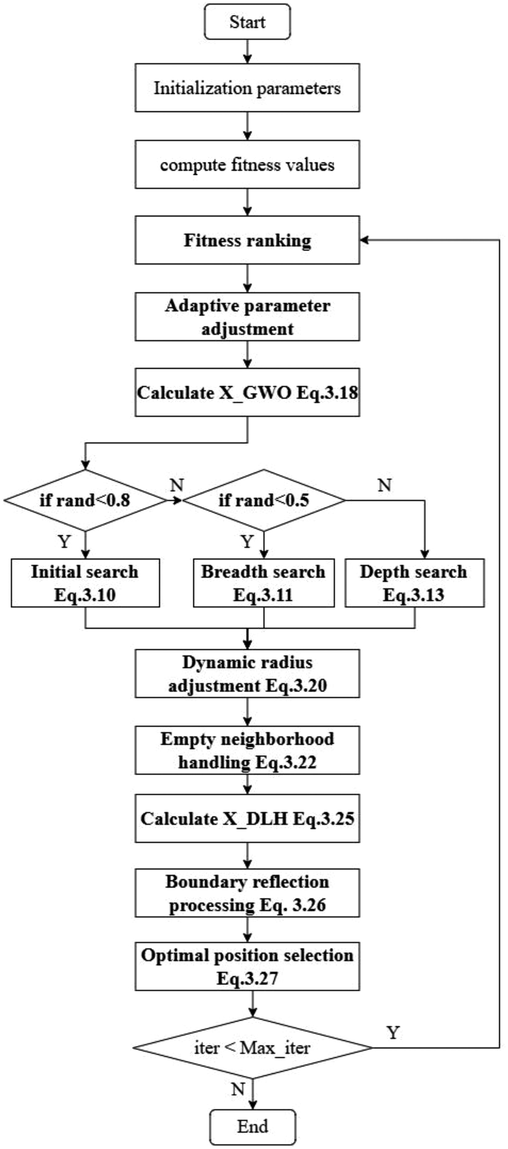
AIGWO algorithm flow

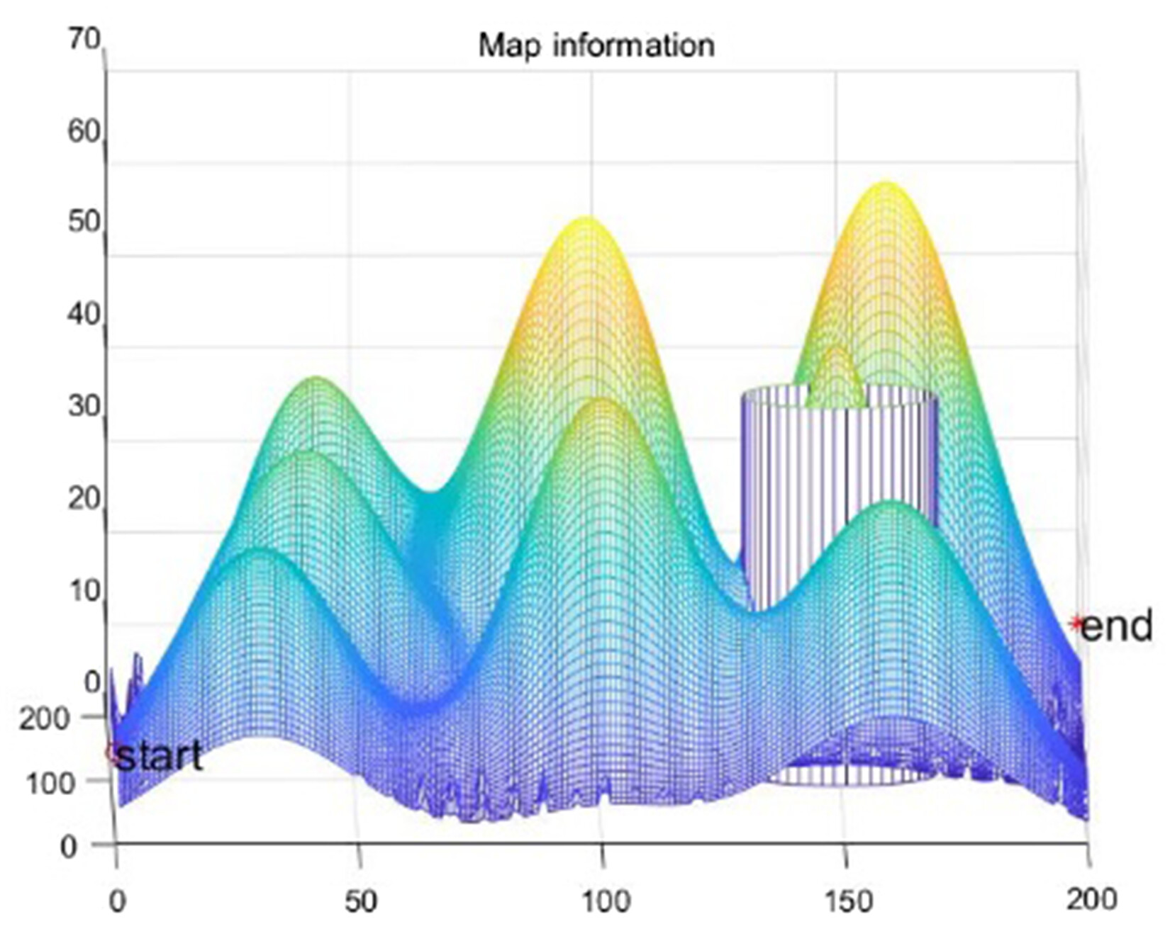
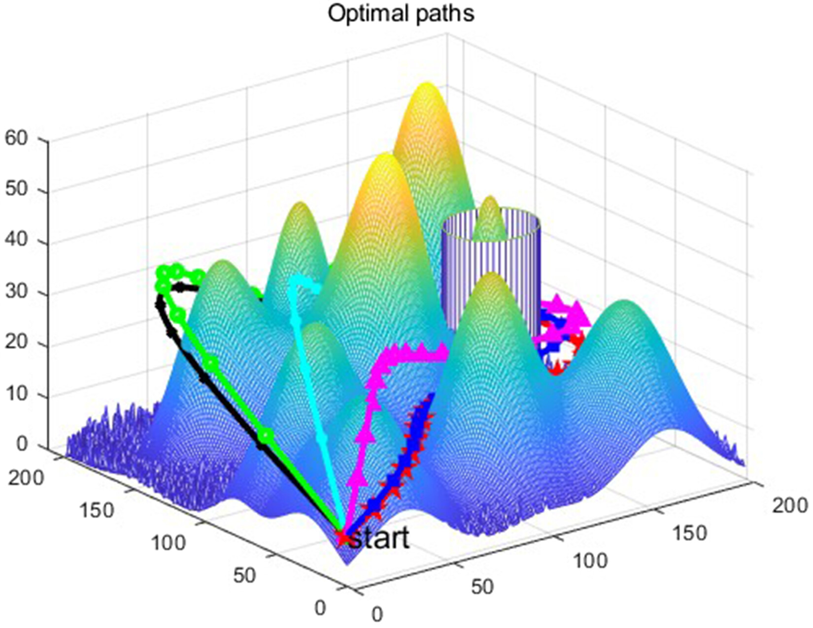
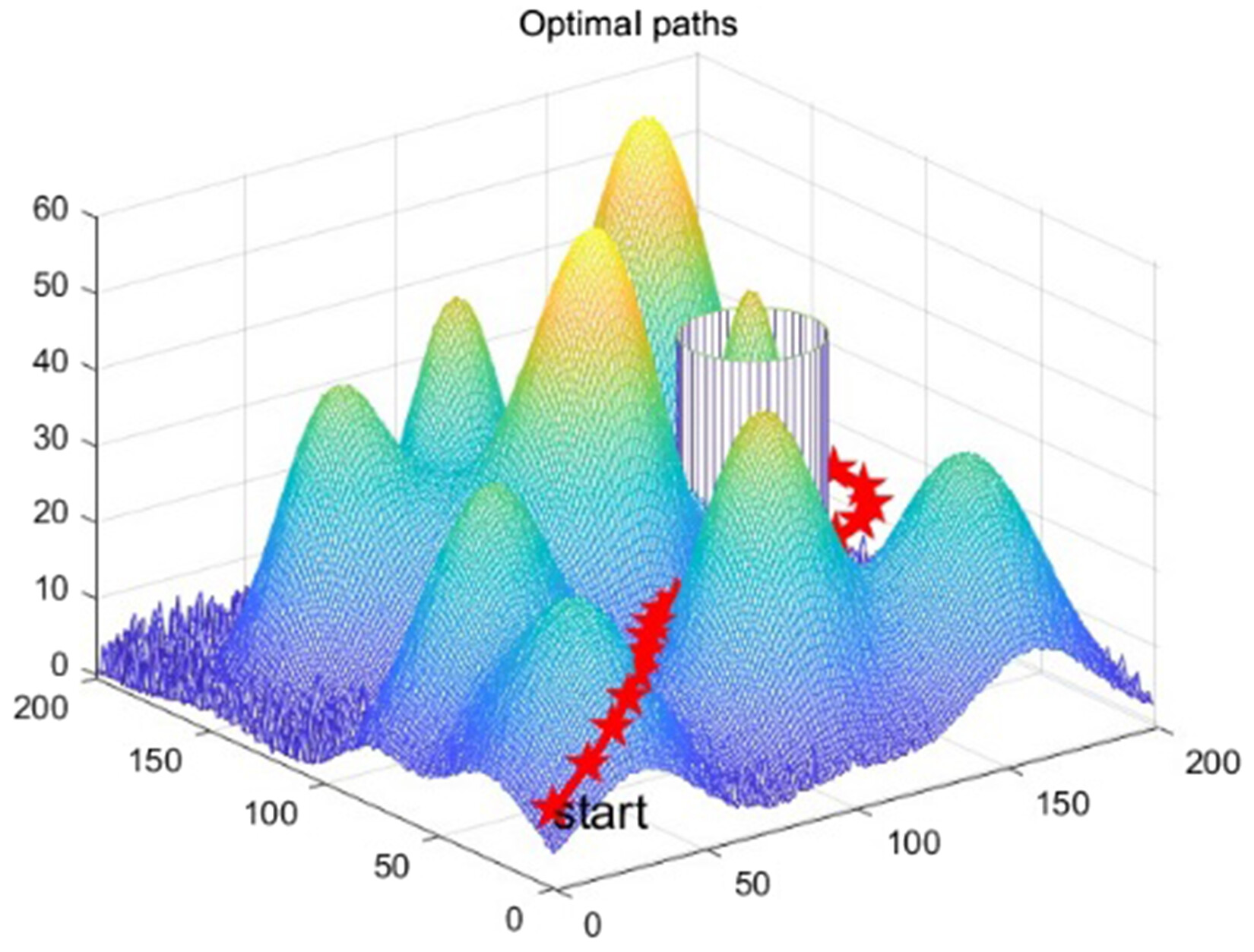
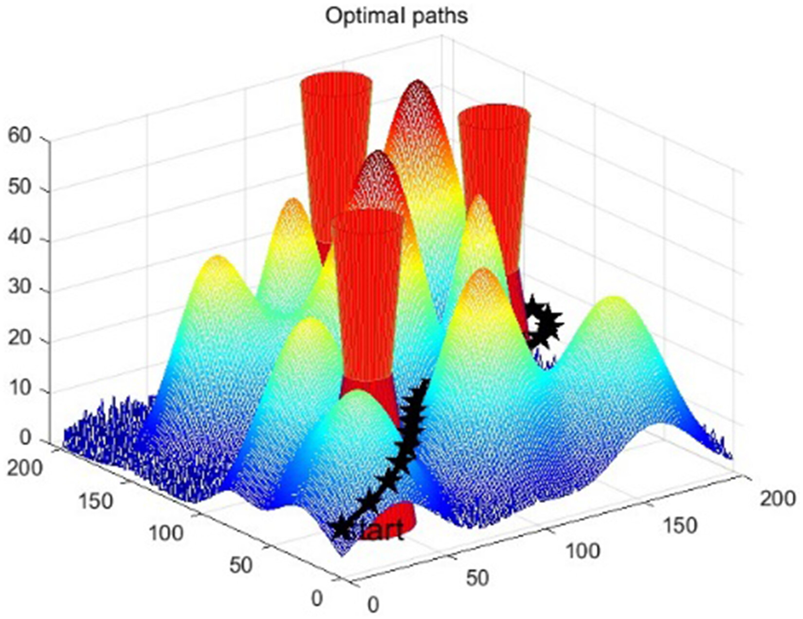
The flow of the AIGWO algorithm for UAV mountainous transportation path planning is illustrated in Figure 1, and the main steps are described as follows:
Step 1: Initialization.
Figure 1. Flowchart of the AIGWO algorithm.
Set the maximum number of iterations T, population size N, upper/lower bounds ud,ld, and other parameters. Randomly generate the initial positions of the wolf pack and compute the fitness values in parallel.
Step 2: Fitness ranking.
Sort the fitness values, record the positions Xα,Xβ,Xδ and fitness values of the top three wolves.
Step 3: Adaptive parameter adjustment.
Calculate the population diversity ratio γ and adjust the decay factor using (equations (22)–(24)). Compute the XGWO through dynamic weight assignment (equation (33)).
Step 4: Search method switching.
Probabilistically select one of the initial, breadth, or depth search modes and update the positions of the wolves accordingly (equations (25), (26) and (28)).
Step 5: Candidate position generation.
Compute XDLH dynamic radius adjustment, empty neighborhood handling, and neighbor selection (equations (35), (37) and (40)). Apply boundary reflection processing to keep solutions within feasible bounds (equation (41)).
Step 6: Optimal position selection.
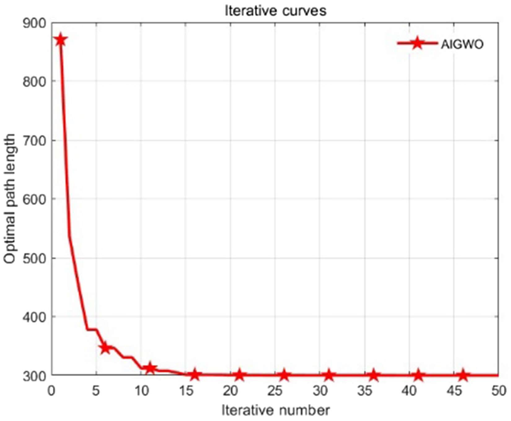
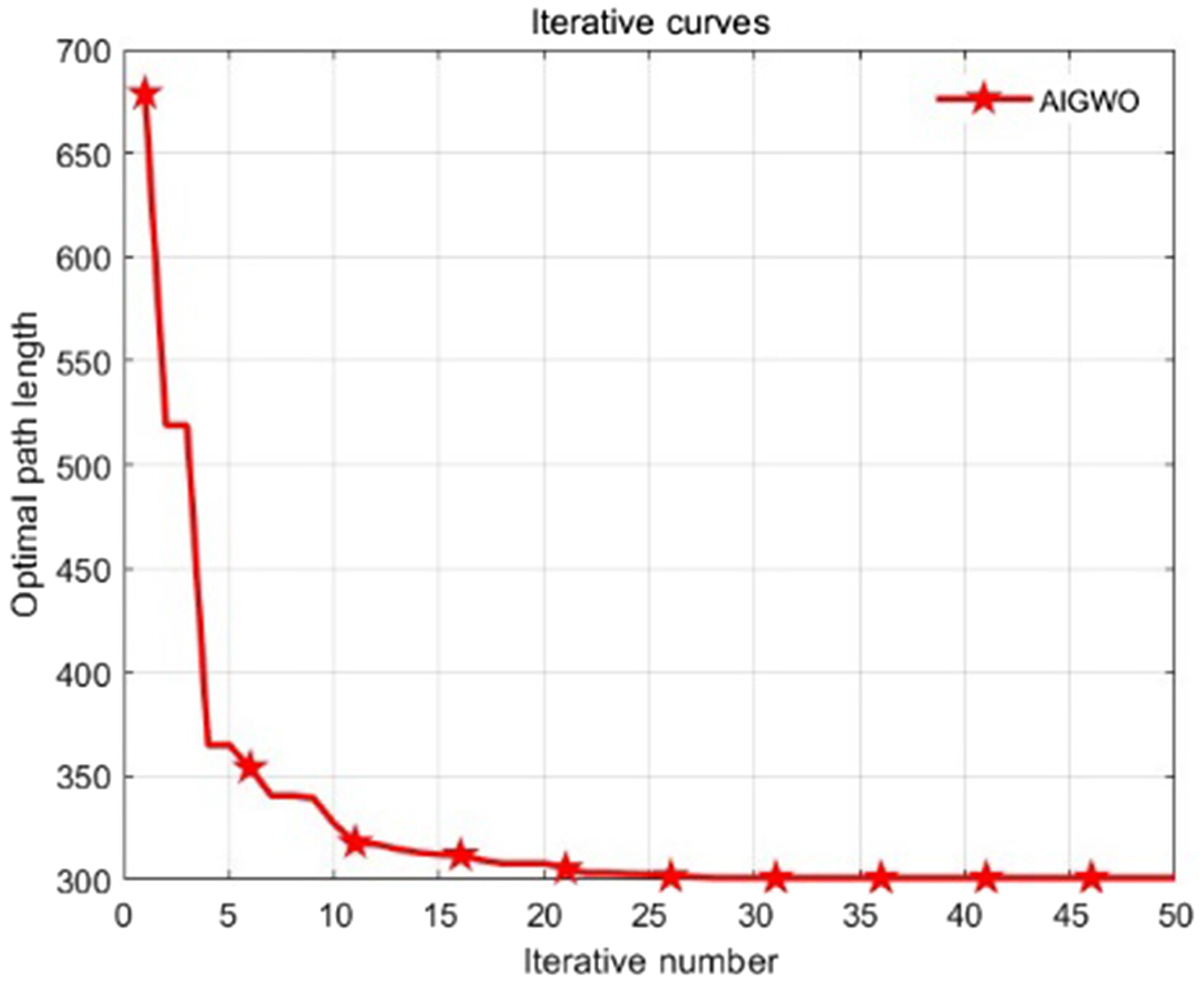
Update the swarm position using (equation (42)) and record the convergence curve.
Step 7: Termination check.
If the maximum number of iterations is reached, output the optimal path; otherwise, return to Step 2.

Core advantages over GWO variants

To highlight the novelty of AIGWO relative to incremental combinations of existing strategies, a targeted comparison was conducted with representative GWO variants (Aquila Exploration Grey Wolf Optimizer (AGWO),33 Lévy-embedded Grey Wolf Optimizer (LGWO),34 and Improved Grey Wolf Optimizer (IGWO)35) commonly applied in UAV path planning. These variants typically rely on static or isolated enhancements: AGWO only adjusts the convergence factor adaptively, IGWO optimizes solely the random weight in position updates, and LGWO uses a fixed-radius local search.
In contrast, AIGWO's superiority arises from its scenario-specific, dynamic, and synergistic integration designed specifically for UAV transportation in complex mountainous environments. In particular, the adaptive decay factor is adjusted dynamically based on population diversity and is tightly integrated with three multi-scale search strategies as well as a dimension-learning-based candidate position update mechanism. This coordinated mechanism enables real-time tuning of the exploration–exploitation balance in response to convergence feedback, thereby effectively mitigating the limitations of prior variants, such as inadequate multi-objective adaptation and limited robustness against dynamic obstacles.
Moreover, the multi-objective evaluation function is tailor-made to prioritize practical mission constraints rather than generic optimization metrics. As demonstrated in section “Experimental design and result analysis,” this holistic design allows AIGWO to outperform GWO variants in high-dimensional, multi-constrained, and uncertain mountainous scenarios, delivering a better trade-off among convergence speed, solution quality, and environmental robustness. These results substantiate that AIGWO is not merely a simple hybrid but a mission-oriented innovation.

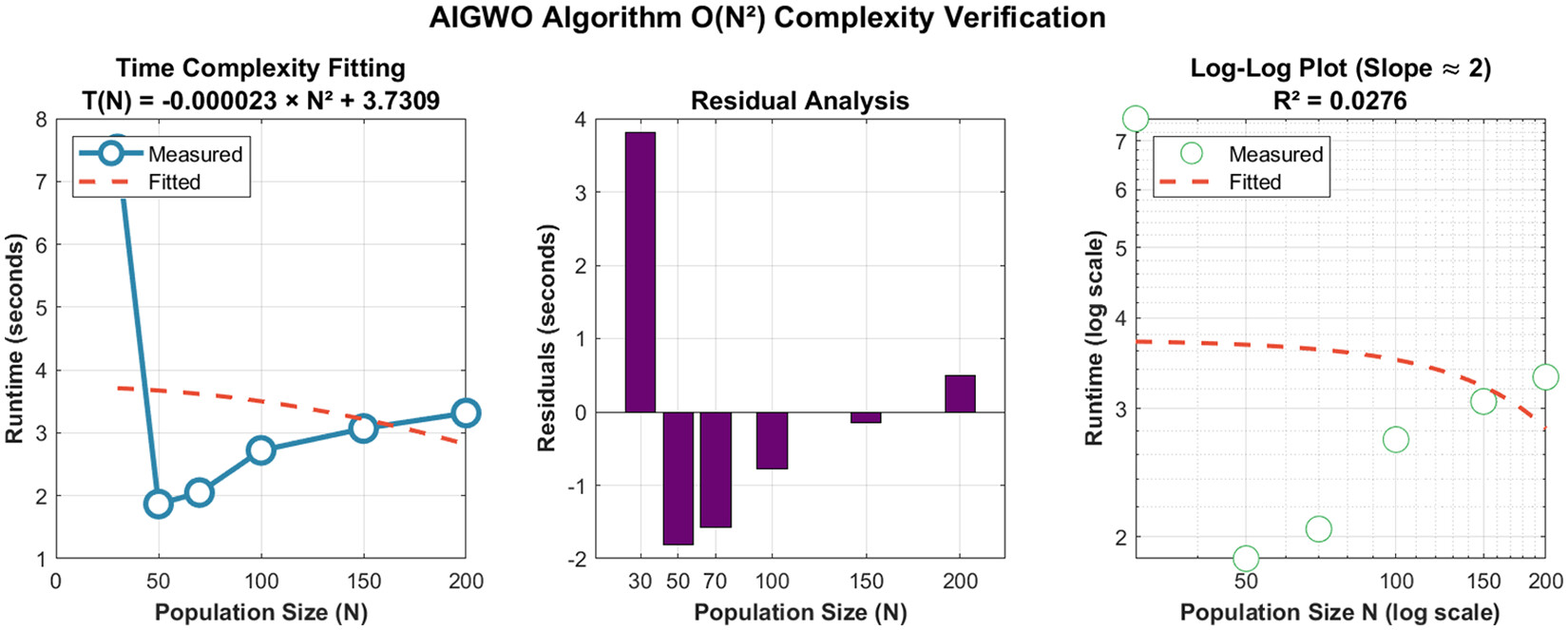
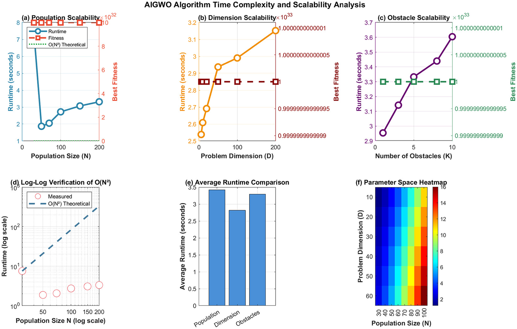
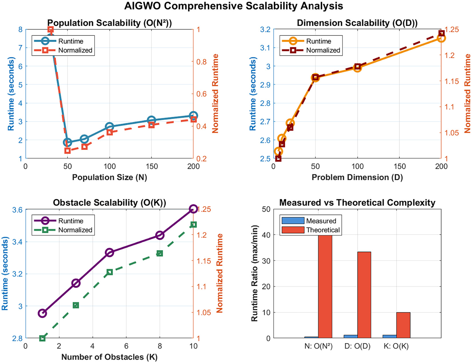
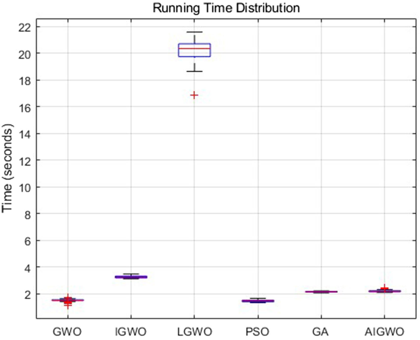
Time complexity and scalability analysis

To assess the practical applicability of AIGWO in UAV path planning, its time complexity and scalability with respect to population size (N), problem dimensionality (D), and obstacle count (K) were comprehensively evaluated.

Time Complexity Analysis

The total time complexity of AIGWO is O(T×N×D), where T denotes the maximum number of iterations, N represents the population size and D stands for the problem dimensionality. This polynomial complexity is consistent with the original GWO (O(T×N×D)). Despite the introduction of adaptive mechanisms and additional modules, the computational overhead remains manageable and does not lead to exponential growth.

Scalability Evaluation

Scalability was evaluated under standardized experimental conditions, using average runtime as the primary metric. Controlled experiments isolated the impact of each parameter by varying one while fixing the others at baseline values (N=50,D=10,K=5). For each configuration, the algorithm ran for 50 iterations over 3 independent runs, and average runtime was recorded.
1.
Population Size (N) Scalability
Population sizes were varied from 30 to 200. Runtime increased significantly from approximately 1.87 to 3.32 s. As shown in Figure 2, this trend exhibits clear quadratic behavior, confirmed by curve fitting to the model (T(N)=0.000023N2+3.7309). This confirms that population size dominates computational cost, consistent with the O(N2) term arising from inter-agent interactions in the core loop (Figure 3).
2. Scalability with Respect to D and K
Figure 2. O(N2) complexity verification for AIGWO.
Figure 3. AIGWO time complexity and scalability.
When D increased from 6 to 200, runtime rose moderately and approximately linearly from 2.54 to 3.15 s, verifying the O(D) contribution primarily from waypoint-based fitness evaluations and position updates.
When K increased from 1 to 10, runtime increased modestly from 2.95 to 3.60 s, indicating O(K) complexity due to obstacle collision checking.
1.
Comprehensive Validation
Normalized runtime analysis (Figure 4) further confirmed the hierarchical impact of the parameters: N(O(N2)) exerted the strongest influence, while D(O(D)) and K(O(K)) imposed manageable linear effects. The close alignment between empirical trends and theoretical complexity validates the analysis.
Figure 4. AIGWO comprehensive scalability analysis.
In summary, AIGWO demonstrates predictable and manageable scaling behavior: quadratic growth with N and linear growth with D and K. The dominant O(N2) term underscores the importance of strategic population size selection to balance solution quality and computational efficiency, thereby confirming AIGWO's practical viability for real-world UAV path planning across varying problem scales.

Experimental design and result analysis

Experimental environment

All simulation experiments were implemented on the MATLAB R2023b platform, with the spatial dimension of experimental simulation environment configured as 200×200×60. A map model (Figure 5) was established for UAV transportation path planning in complex mountainous areas, incorporating a start point, an end point, mountainous terrain with variable elevations and slopes, and closed cylindrical threat zones. The mountainous terrain was designed to maximize the simulation of real topographical features of mountainous regions.
Figure 5. Map model.
The core mission constraint is that the UAV is required to complete the transportation task by navigating from the start point to the end point, with strict avoidance of collisions with mountainous terrain and incursions into threat zones; any collision or intrusion is defined as mission failure. To comprehensively assess the performance of path planning algorithms for UAV transportation in mountainous areas, key evaluation metrics were adopted, including algorithm runtime, total planned path length, algorithm convergence speed, and optimal fitness value.

Parameter sensitivity analysis

To address concerns regarding the additional parameters in AIGWO and to identify optimal values that enhance optimization stability, sensitivity analysis was performed on three key parameters: the decay rate (λ), the Lévy flight step-size constant (Levys), and the weight parameters (ω1/ω2/ω3). The mean fitness value and the number of convergence iterations served as primary performance metrics. Line plots were used to illustrate variations in these metrics with parameter changes, while heatmaps visualized sensitivity distributions across the parameter space.
For the decay rate (λ), the analysis covered the range [4.5, 5.5]. As shown in the left subfigure of Figure 6, the mean fitness reaches its peak when λ5, while the number of convergence iterations remains relatively low. The corresponding heatmap in the left subfigure of Figure 7 exhibits a pronounced color gradient, confirming that λ is highly sensitive. Therefore, fine-tuning is essential, and λ5 was selected as the optimal value based on the results.
Figure 6. Parameter sensitivity.
Figure 7. Parameter sensitivity heatmaps.
For the Lévy flight step-size constant (Levys), the range [0.005, 0.015] was examined. The middle subfigure of Figure 6 indicates superior algorithm performance when s0.009. The middle heatmap in Figure 7 shows significant color variation, verifying high sensitivity. Accordingly, s=0.009 was adopted as the optimal setting following systematic evaluation.
For the weight parameters (ω1/ω2/ω3), various combinations were tested. The right subfigure of Figure 6 reveals negligible differences in mean fitness across combinations, with tightly clustered error bars. The right heatmap in Figure 7 displays a relatively uniform color distribution, indicating low sensitivity to performance. Consequently, the weights were fixed at a balanced configuration (ω1=0.4,ω2=0.4,ω3=0.2). This setting aligns with the demands of UAV transportation in complex mountainous environments: balanced emphasis on path length and flight altitude ensures operational efficiency and safety in rugged terrain, while a moderate weight for turning angle accommodates constrained maneuvering conditions. Thus, this proportion is deemed reasonable for the target scenario.
In summary, the sensitivity analysis determined optimal values for highly sensitive parameters (λ=5,s=0.009) and justified fixed values for the weakly sensitive weight parameters. This approach not only preserves AIGWO's performance advantages but also maintains reasonable algorithmic simplicity.

Algorithm comparison experiment

To validate the superiority of the AIGWO algorithm for UAV transportation path planning in complex mountainous terrain, comparative simulation experiments were conducted using five benchmark algorithms: GWO, LGWO, IGWO, PSO, and GA. To ensure fair comparability, all algorithms shared the same baseline parameters: 50 iterations, a population size of 70, and were executed over 40 independent runs.
Table 1 summarizes the average results from the 40 independent runs for each algorithm, including key metrics: best fitness, runtime, number of convergence iterations, and path length. These provide a quantitative foundation for comprehensive performance evaluation.
Table 1. Algorithm data comparison.
AlgorithmBest fitnessRuntimeIterationsPath length
GWO14353.191.5223.63371.37
IGWO11319.433.2731.85362.30
LGWO34341.0020.1921.05370.75
PSO9345.521.4828.70361.44
GA35501.172.1620.88381.65
AIGWO290.302.2215.00352.45
Bold text is applied to the best-performing values within each column to emphasize the optimal results among the compared methods.
Core performance aspects (convergence behavior, solution quality, and computational efficiency) were analyzed using these data, with results visualized in Figures 8 to 12.
Figure 8. Route planning map.
Figure 9. Average convergence curves comparison.
Figure 10. Convergence curves comparison (Run 40).
Figure 11. Distribution of best fitness scores.
Figure 12. Running time distribution.
Convergence Performance: Figure 9 shows the average convergence curves across all test runs. AIGWO exhibits a faster convergence rate and reaches a lower stable best fitness value. Within the first 10 iterations, its average best fitness decreases sharply and stabilizes at a low level, whereas the other algorithms display slower descent trends. Figure 10 presents the convergence curve from the 40th independent run, which closely aligns with the average trend and confirms AIGWO's robust and stable convergence behavior. Quantitatively, Table 1 indicate that AIGWO requires only 15.00 average iterations to stabilize—[36.5%] less than GWO (23.63), [53.0%] less than IGWO (31.85), [28.8%] less than LGWO (21.05), [47.7%] less than PSO (28.70), and [28.1%] less than GA (20.88)—further confirming its superior convergence efficiency.
Solution Quality: Figure 11 illustrates the statistical distribution of best fitness values across all runs. AIGWO shows the lowest median and the most concentrated distribution, indicating superior path optimization capability and result stability. Table 1 further confirms this: AIGWO's average best fitness (290.30) is [17.8%] lower than GWO (353.19), [9.1%] lower than IGWO (319.43), [14.9%] lower than LGWO (341.00), [16.0%] lower than PSO (345.52), and [42.1%] lower than GA (501.17). Regarding path length, AIGWO's average (352.45) is [5.1%] shorter than GWO (371.37), [2.7%] shorter than IGWO (362.30), [5.0%] shorter than LGWO (370.75), [2.5%] shorter than PSO (361.44), and [7.7%] shorter than GA (381.65). Figure 8 visualizes the optimal paths in complex mountainous terrain, where AIGWO generates an obstacle-free, constraint-compliant path of higher quality than those produced by the baseline algorithms.
Computational Efficiency: Figure 12 depicts the runtime distribution across all algorithms. LGWO has a significantly longer runtime (20.19 s) than the others, while AIGWO (2.22 s) is comparable to GWO (1.52 s), PSO (1.48 s), and GA (2.16 s). Even with extra adaptive mechanisms, AIGWO remains efficient enough for practical UAV applications.
In summary, the comprehensive comparative experiments and quantitative analysis demonstrate AIGWO's superiority in convergence speed, path optimization quality, and result stability. Its acceptable computational efficiency further supports its suitability for UAV 3D path planning in complex mountainous environments.

Wilcoxon signed-rank test

To determine whether the performance differences between the proposed AIGWO and the benchmark algorithms (GWO, IGWO, LGWO, PSO, and GA) are statistically significant, the Wilcoxon signed-rank test was performed.
The test treated AIGWO as the reference algorithm; best fitness values from 30 independent runs for each algorithm were used as paired samples. The null hypothesis (H0) stated that there is no significant difference in the median best fitness between AIGWO and each benchmark algorithm. A significance level of α=0.05 was adopted, with Bonferroni correction applied to account for multiple comparisons (5 pairs, adjusted α=0.01). Cohen's r was computed as the effect size, where r0.5 indicates a large effect.
Table 2 presents the descriptive statistics of the best fitness values across all algorithms. AIGWO achieved the lowest mean (284.37) and smallest standard deviation (8.49), suggesting superior and more stable path optimization.
Table 2. Descriptive statistics of best fitness values.
AlgorithmMeanStd. dev.MedianMinMax
AIGWO284.378.49280.13276.09304.93
LGWO331.3147.46363.59276.80383.67
GWO338.5156.87335.02278.58475.83
IGWO344.5153.39372.17277.97445.30
PSO357.0477.77324.06279.60550.74
GA483.2985.60462.76300.73681.39
Bold text is applied to the best-performing values within each column to emphasize the optimal results among the compared methods.
Table 3 reports the Wilcoxon signed-rank test results. All Bonferroni-corrected p-values were below 0.01, leading to rejection of H0 in every pairwise comparison. Cohen's r values all exceeded 0.5, indicating large practical effect sizes.
Table 3. Wilcoxon signed-rank test results.
ComparisonOriginal p-ValueCorrected p-ValueSignificant?Cohen's r
GWO vs. AIGWO8.92×10−054.46×10−04Yes0.72
IGWO vs AIGWO1.89×10−049.45×10−04Yes0.68
LGWO vs AIGWO5.71×10−042.85×10−03Yes0.63
PSO vs AIGWO1.97×10−059.86×10−05Yes0.78
GA vs AIGWO1.73×10−068.67×10−06Yes0.87
The bold formatting used to denote the significance.
These results provide strong statistical evidence that AIGWO significantly outperforms GWO, IGWO, LGWO, PSO, and GA in path optimization quality (all comparisons significant at the adjusted α=0.01 level). The large effect sizes further indicate that the performance improvement is practically meaningful, supporting the effectiveness of the proposed AIGWO for UAV path planning in complex mountainous environments.

Robustness analysis

To investigate the AIGWO algorithm's robustness in complex uncertain mountainous transportation scenarios, experiments were performed via introducing random noise and constructing dynamic obstacle models to simulate real mountainous operational environments. To simulate mountainous terrain uncertainty, Gaussian noise was superimposed on the basic terrain function to align the simulated environment with actual mountainous topographic fluctuations. For dynamic obstacles, mathematical formulas defined multi-modal motion rules of typical mountainous transportation obstacles, including temporary rockfalls and moving vehicles. A high-fidelity, highly customizable dynamic test environment was built to comprehensively evaluate the algorithm's robustness to dynamic changes in these scenarios (Figures 1316).
Figure 13. Introduction of random noise path figure.
Figure 14. Iterative plot of introducing random noise adaptation values.
Figure 15. Introduction of dynamic obstacle paths figure.
Figure 16. Iterative plot for introducing dynamic obstacle adaptation values.
The experimental data of the AIGWO algorithm tested in three distinct environments (original mountainous map, map with random noise, and map with dynamic obstacles) are presented in Table 4.
Table 4. Experimental data for testing in three different environments.
 TimeOptimal fitness valuePath lengthConvergence rate
AIGWO2.56289.33346.8415.73
Random noise3.68286.07348.8713.38
Dynamic disturbance4.90282.64349.7714.78
Bold text is applied to the best-performing values within each column to emphasize the optimal results among the compared methods.
Based on the comparative analysis of 40 sets of experimental data, minor fluctuations were observed in the algorithm's performance metrics when random noise and dynamic obstacles were introduced into the mountainous environment. However, all fluctuations were within the acceptable range. Through these experiments, the robust performance of the AIGWO algorithm in complex and uncertain mountainous transportation scenarios was effectively validated.

Summary

To address the challenges in UAV transportation path planning in complex mountainous areas—such as unstructured terrain, dynamic obstacle interference, and the slow convergence and tendency to become trapped in local optima of traditional algorithms—this paper proposes an AIGWO algorithm. The main conclusions are as follows: A 3D spatial model tailored to real mountainous environments and a scientifically designed multi-objective evaluation function were constructed. The 3D model integrates static terrain, dynamic obstacles with multiple motion patterns, and random noise, thereby accurately representing the complex conditions of mountainous transportation. The multi-objective function quantitatively evaluates path quality across three key dimensions: path length (for energy efficiency), flight altitude (for safety), and turning angle (for flight stability). The weight configuration (ω1=0.4,ω2=0.4,ω3=0.2) is well suited to the requirements of mountainous transportation tasks. Two core improvement strategies were designed to overcome the limitations of the standard GWO. The adaptive search strategy dynamically balances global exploration and local exploitation by adjusting the attenuation factor based on population diversity and switching flexibly among initial search, breadth search, and depth search modes, significantly improving convergence speed. The candidate position update strategy based on dimensional learning enhances population diversity through neighborhood construction, adaptive weight assignment, and boundary reflection, effectively preventing premature convergence to local optima and strengthening local optimization capability. Comprehensive experiments confirmed the superior performance of AIGWO. Across 40 independent runs, AIGWO outperformed the advanced algorithms (GWO, IGWO, LGWO, PSO, and GA): the average number of convergence iterations was only 15.00, representing a 36.5% reduction compared to standard GWO and an average 38.8% reduction relative to the other benchmarks; the average path length was reduced to 352.45, with a 5.1% improvement over GWO and 7.7% over GA; the average best fitness reached 290.30, showing a 17.8% improvement over GWO and 42.1% over GA. Under random noise and dynamic obstacle interference, performance fluctuations remained within acceptable limits, demonstrating good robustness. Moreover, the average runtime (2.22 s) stayed reasonable, indicating strong potential for real-world application.
Future work may focus on integrating deep reinforcement learning to develop an intelligent waypoint prediction model, further enhancing path planning accuracy and stability. The algorithm could also be extended to multi-UAV collaborative transportation scenarios to improve coordinated obstacle avoidance and resource allocation efficiency, thereby meeting more demanding mountainous transportation requirements.

Declaration of conflicting interests

The authors declared no potential conflicts of interest with respect to the research, authorship, and/or publication of this article.

Funding

The authors disclosed receipt of the following financial support for the research, authorship, and/or publication of this article: This work was supported by the Zhengzhou University of Light Industry.

ORCID iD

References

1. Ma ZY, Chen J. Adaptive path planning method for UAVs in complex environments. Int J Appl Earth Obs Geoinf 2022; 115: 103133.
2. Fan J, Zhang XD, Zou Y. Hierarchical path planner for unknown space exploration using reinforcement learning-based intelligent frontier selection. Expert Syst Appl 2023; 230: 120630.
3. Nulty MDR, Mech LD, Smith DW. A proposed ethogram of large carnivore predatory behavior, exemplified by the wolf. J Mammal 2007; 88: 595–605.
4. Dijkstra EW. A note on two problems in connexion with graphs. Numer Math 1959; 1: 269–271.
5. Hart PE, Nilsson NJ, Raphael B. A formal basis for the heuristic determination of minimum cost paths. IEEE Trans Syst Sci Cybern 1968; 4: 100–107.
6. Zhang R, Zong Q, Zhang X, et al. Game of drones: multi-UAV pursuit-evasion game with online motion planning by deep reinforcement learning. IEEE Trans Neural Netw Learn Syst n.d.; 10: 7900–7909.
7. Sun XH, Deng SC, Tong BH, et al. Hierarchical framework for mobile robots to effectively and autonomously explore unknown environments. ISA Trans 2023; 134: 1–15.
8. Zhou WH, Li J, Liu ZH, et al. Improving multi-target cooperative tracking guidance for UAV swarms using multi-agent reinforcement learning. Chin J Aeronaut 2022; 35: 100–112.
9. Kennedy J. Particle swarm optimization. Proc. 1995 IEEE Int. Conf. Neural Netw (Perth, Australia) 1995; 4: 1942–1948.
10. Dorigo M, Birattari M, Stutzle T. Ant colony optimization. Comput Intell Mag, IEEE 2006; 1: 28–39.
11. Nadimi-Shahraki MH, Taghian S, Mirjalili SA. An improved grey wolf optimizer for solving engineering problems. Expert Syst Appl 2021; 166: 113917.
12. Tian SS, Li YX, Zhang X, et al. Fast UAV path planning in urban environments based on three-step experience buffer sampling DDPG. Digit Commun Netw 2024; 10: 813–826.
13. Wang WT, Li XL, Tian J. UAV formation path planning for mountainous forest terrain utilizing an artificial rabbit optimizer incorporating reinforcement learning and thermal conduction search strategies. Adv Eng Inf 2024; 62: 102947.
14. Mirjalili S, Mirjalili SM, Lewis A. Grey wolf optimizer. Adv Eng Softw 2014; 69: 46–61.
15. Liu XY, Li GQ, Yang HY, et al. Agricultural UAV trajectory planning by incorporating multi-mechanism improved grey wolf optimization algorithm. Expert Syst Appl 2023; 233: 120946.
16. Banaie-Dezfouli M, Nadimi-Shahraki MH, Beheshti Z. BE-GWO: binary extremum-based grey wolf optimizer for discrete optimization problems. Appl Soft Comput 2023; 146: 110583.
17. Duan YC, Yu XB. A collaboration-based hybrid GWO-SCA optimizer for engineering optimization problems. Expert Syst Appl 2023; 213: 119017.
18. Yu XB, Jiang NJ, Wang XM, et al. A hybrid algorithm based on grey wolf optimizer and differential evolution for UAV path planning. Expert Syst Appl 2023; 215: 119327.
19. Kiani F, Seyyedabbasi A, Aliyev R,. et al. 3D Path planning method for multi-UAVs inspired by grey wolf algorithms. J Internet Technol 2021; 22: 743–755.
20. Kiani F, Seyyedabbasi A, Aliyev R, et al. Adapted-RRT: novel hybrid method to solve three-dimensional path planning problem using sampling and metaheuristic-based algorithms. Neural Comput Appl 2021; 33: 15569–15599.
21. Kiani F, Seyyedabbasi A, Nematzadeh S, et al. Adaptive metaheuristic-based methods for autonomous robot path planning: sustainable agricultural applications. Appl Sci 2022; 12: 943.
22. Kiani F, Nematzadeh S, Seyyedabbasi A. Designing a dynamic protocol for real-time Industrial Internet of Things-based applications by efficient management of system resources. Adv Mech Eng 2019; 11: 1–10.
23. Anka F, Gharehchopogh FS, Tejani GG, et al. Advances in mountain gazelle optimizer: a comprehensive study on its classification and applications. Int J Comput Intell Syst 2025; 18: 247.
24. Anka F. A multi-strategy chimp optimization algorithm for solving global and constraint engineering problems. Knowl Inf Syst 2025; 67: 6753–6802.
25. Anka F. A novel hybrid metaheuristic method for efficient decentralized IoT network layouts. Internet of Things 2025; 32: 101612.
26. Anka F, Aghayev N. Advances in sand cat swarm optimization: a comprehensive study. Arch Computat Methods Eng 2025; 32: 2669–2712.
27. Chen H, Wei FQ, Han CZ. UAV Path planning strategy based on threat avoidance in multiple extended target tracking optimization. J Radars 2023; 12: 529–540.
28. Gatziolis D, Fried JS. Adding Gaussian noise to inaccurate digital elevation models improves spatial fidelity of derived drainage networks. Water Resour Res 2004; 40: W02508 (1–10).
29. Grohmann CH, Smith MJ, Riccomini C. Assessing the Impact of Uncertainties of Digital Elevation Models on Hydro Geomorphological Analysis Using Gaussian White Noise. In: EGU General Assembly Conference Abstracts, 2020.
30. Cao J, Chang DC, Fu ZW,. et al. Real interpolation of weighted tent spaces. Appl Anal 2016; 95: 2415–2443.
31. Xing YZ, Wang DH. An improved Grey Wolf optimization algorithm based on convergence factor. Netw New Media Technol 2019; 9: 28–34.
32. Eid A, Kamel S. Optimal Allocation of Multiple Distributed Generations in Radial Distribution Systems Using Levy Flight Distribution Algorithm. In: IEEE International Conference on Automation Congress of the Chilean Association of Automatic Control (ICA-ACCA), 2021, (pp. 1–5). Valparaíso, Chile.
33. Ma C, Huang H, Fan Q, et al. Grey wolf optimizer based on Aquila exploration method. Expert Syst Appl 2022; 205: 117629.
34. Heidari AA, Pahlavani P. An efficient modified grey wolf optimizer with Lévy flight for optimization tasks. Appl Soft Comput 2017; 60: 115–134.
35. Bonabeau E, Dorigo M, Theraulaz G. Swarm intelligence: from natural to artificial systems. New York, NY, USA: Oxford University Press, 1999. (online edn, Oxford Academic, 12 Nov. 2020).